


_edited_edited.jpg)

What is Stormwater?
Stormwater is the water form of any type of precipitation such as rain or melted snow. Stormwater becomes a problem when excessive amounts of "runoff" water flow across the land surface.


The Problem with Stormwater
There is not just one source of pollution. It's everywhere.
Pollution
As water runoff flows across the ground's surfaces, it picks up what it touches. The further it travels over land, the more polluted it becomes.
Unless something intercepts it, the runoff carries dirt, chemicals, and other pollutants directly to our streams and waterways.
Flooding
When rain falls on hard surfaces, like roads and roofs, it runs off in channels that are not quickly absorbed. The runoff water moves far down stream to lowland areas where all the flows combine. The combined channels of water can overwhelm the infrastructure, cause erosion and flooding damage
Stormwater Solutions

There is not just one solution to pollution. It's everywhere.
Reduce Pollution Sources
-
Use natural yard care techniques.
-
Avoid pesticide use.
-
Reduce use of fertilizers.
-
Maintain septic systems.
-
Fix oil leaks.
-
Pick up pet waste.
Reduce Runoff
-
Increase water infiltration by improving the soil with compost.
-
Replace unused lawns with trees, shrubs, and other plants.
-
Water harvesting techniques, such as rain barrels and rain gardens.
-
Other L.I.D. practices, such as porous paving or “Green Roofs”.


Marine Biotoxin Monitoring Program


The Marine Biotoxin Monitoring Program assists the WA State Department of Health monitor local recreational shellfish harvesting beaches during the HABs (Harmful Algal Blooms) season for Paralytic Shellfish Poisoning (PSP), Diarrhetic Shellfish Poisoning (DSP) and Amnesic Shellfish Poisoning. PSP is a serious illness caused by eating shellfish that have consumed large amounts of toxins. DSP has recently been detected in Puget Sound waters. Regular monitoring allows a quick response of closing beaches when toxins levels are high to assure the safety of the public's health.

Who can Volunteer
Adults, 18+ in Skagit County who are interest in public health and the Salish Sea can participate.
Time Commitment
The volunteer time commitment for this program includes completing the 2-day training, then approximately 4 to 6 hours a month from mid-April through September (during daytime low tides).
Training

The 2 days of training are held in early spring, between mid-March and the end of April. (The dates are selected based on the tides.) The first training is done virtually and the second training is done on the beach during a low tide. Volunteers will learn about Paralytic Shellfish Poisoning (PSP), Diarrhetic Shellfish Poisoning (DSP) and Amnesic Shellfish Poisoning and its effect on humans, how to identify our local clams, and about the Shellfish industry processing in our area.
Task
Volunteers with their teammate(s) will harvest, by hand, the shellfish present at their assigned local Skagit beaches which are then sent to the Dept. of Health Lab to be tested.

Training Dates
Training occurs yearly around the end of March / early April and will include 1 (Virtual) training session and 1 (on the beach) training session, TBD
Announcements will be posted in our quarterly E-Newsletter.
For more information contact Carla Glassman,


Storm Drain Marking
Join us in protecting our local waterways by organizing a storm drain marking project for neighborhoods in unincorporated Skagit County and the cities of Burlington and Mount Vernon. Colorful markers are now available to be placed on storm drains in an effort to educate the public and reduce pollutants from entering our streams.

Stream Team
The Skagit Stream Team is a network of citizens concerned about the health of local streams. They are trained to work in teams to collect water quality data on stream reaches located in our priority watersheds: Nookachamps Creek Watershed; Padilla Bay Watershed; and Samish Watershed, as well as sampling stormwater runoff in the cities of Anacortes, Burlington and Mount Vernon. Each team tests for temperature, fecal coliform, turbidity, depth, and dissolved oxygen and averages around 4-6 hours per month.

SPONSORED BY: Skagit Conservation District, Padilla Bay National Estuarine Research Reserve, City of Anacortes, City of Burlington, City of Mount Vernon, and Skagit County

A Citizen Volunteer Water Quality Monitoring Program
Key Roles:
Stream Team Field Monitors: Responsible for collecting and recording water quality data at assigned stream reaches on a monthly basis.
Please note that this position may require walking on rocky, steep, and/or uneven terrain.
Stream Team Lab Managers: Trained to conduct fecal coliform and turbidity tests at the Padilla Bay Research Reserve lab facility.
Data Managers: Maintains monitoring and lab data, while generating graphs and charts for the year end monitoring report.
All Stream Team Volunteers learn new skills, gain new insights, network with local experts, meet new friends, and participate in a worthwhile community program.
Stream Team Volunteers have access to a manual, equipment, supplies, and FREE TRAINING. Volunteers are covered by L&I Insurance.
The Skagit Stream Team Monitoring Program was established in 1998 to inspire community stewardship of water resources through education and volunteer science. Data from this program are for informational and educational purposes only.

Annual Stream Team Reports
For 2022-23, 2023-24, and onwards, the Stream Team data website serves as the annual report. Click the Data Explorer page button to see current information.
Goals of the Skagit Stream Team Program:
To inspire community stewardship regarding water quality.
To teach community volunteers the sampling and analytical techniques used by professionals that can be used to assess water quality trends, and to characterize existing conditions.
To document improvements in water quality.

The Scoop on Poop
Only you can make pet waste disappear.

Scoop it, Bag it, and Put it in the trash.
-
Pet waste can carry diseases and parasites which can easily be passed on to people and animals that come in contact with it.
-
Pet Waste can take over a year to decay.
-
Parasite eggs in pet waste can live in soil for several years.
(Where they can continue to infect people and pets)
Partner Groups' Volunteer Programs

The goals of the monitoring program are to:
1) Engage community members in hands-on monitoring projects to improve their understanding of forest ecosystems.
2) Gain insight into the stressors on forest ecosystems and the implications of climate change for individual species and forest ecosystems.
3) Provide the City of Anacortes forest managers and the ACFL Forest Advisory Board with environmental monitoring summaries to support forest management.

The Salish Sea Stewards is a volunteer program of the Skagit County Marine Resources Committee in partnership with Padilla Bay National Estuarine Research Reserve.
Our program offers approximately 40 hours of FREE community science training each year focused on the marine environment. In return, participants commit 40 hours of volunteer service in protecting the marine environment over the course of one year.

SFEG is a nonprofit and non-governmental organization, that was formed in 1990 to involve our communities in habitat restoration and watershed stewardship in order to enhance salmon populations.

Conserving wildlife habitat, agricultural and forest lands, scenic open space, wetlands, and shorelines for the benefit of our community and as a legacy for future generations.

Skagit Watershed Council is a community partnership for salmon.
By means of collaboration, technical assistance and education, the watershed council seeks to fulfill their mission, which is to understand, protect and restore the productivity of healthy ecosystems in order to support sustainable fisheries.

Managing Stormwater
Low Impact Development (LID), also known as Rainscaping or Green infrastructure, is a way to prevent stormwater runoff and manage water on site.
The Basics of LID
-
Minimize site disturbance and protect native soils and vegetation
-
Use on-site natural features
-
Manage stormwater close to the source
-
Distributed stormwater Best Management Practices (BMPs)


Water cannot filter through impervious surfaces (like roads, roofs, parking lots, or even developed land that has become compacted). Water from those areas flows across the surface.
Plants decrease runoff by slowing the flow of water and helping the soil to soak up the water. Decreasing runoff reduces soil erosion and the amount of pollutants that end up in our waterways.
Native, mature landscaping is a desired component of LID:
Trees and other vegetation have a 3-5 year establishment period during which they may require additional watering. Maintaining native vegetation reduces the time, effort, and expense of tending to newly planted vegetation.


Preserving natural vegetated areas is one of the best ways to reduce the impact of rainwater and prevent surface water runoff.

Rainwater Dispersion
Rain dispersal systems spread out the flow of water from impervious surfaces into pervious areas, allowing it to slow down and be absorbed into the soil.

Downspouts
can be directed to a water catchment system or directed to areas such as a rain garden, planted area, or gravel filled trench, where it can be absorbed.

Sheet Dispersion
can be used on broad paved areas such as driveways, sidewalks, etc. The pavement is gently sloped to shed water into areas such as a rain garden or planted areas.
Stormwater Solutions - "Green Infrastructure"


Rainwater Catchment
Also known as rainwater harvesting or rainwater collection, it is the simple act of collecting the rainwater that runs off the hardscapes on your site for beneficial use.

Residents of Washington state may harvest rainwater without a permit as long as:
-
it's used on the property from which it was collected
-
it's collected on an existing rooftop
Washington state law even authorizes counties to reduce rates for
stormwater control facilities that utilize rainwater harvesting. Wash. Rev. Code §36.89.080.
Rainwater collection is legal in the State of Washington

Passive methods for rainwater harvesting, include infiltration basins, bio-swales, etc. that slow or stop the flow of runoff across your site. These allow stormwater to infiltrate into the ground, hydrating soils and recharging groundwater.
Active
Active rainwater harvesting catches and stores the water in one or more containers, such as barrels or cisterns for later use. With active rainwater harvesting, you control when, where, and how the water is used.
Passive
Rainwater harvesting makes the most of your resources.
During the summer months it is estimated that nearly 40 percent of household water is used for lawn and garden maintenance. A rain barrel collects water and stores it for those times that you need it most — during the dry summer months.
The average rainfall of one inch within a 24-hour period can produce more than 700 gallons of water that runs off the roof of a typical house.
Harvesting rainwater doesn't have to be a big project. It can just be one rain barrel attached to one gutter that provides convenient water for the chicken yard or for watering a flowerbed without having to drag a hose, etc.
Small systems work fine and expanding your system is fairly easy.
Start by deciding how much water you are hoping to store and where you want to locate it. Placing the barrel higher than where the water will be used allows the use of gravity instead of a pump.
It is best if barrels are able to block out any light that could enter them, to avoid growth of pathogens inside the water.


Permeable Pavement
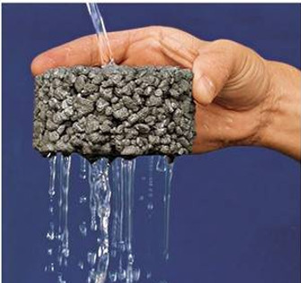
Permeable pavement is a type of pavement with a porous surface that is composed of concrete, open pore pavers, or asphalt with an underlying stone reservoir. It allows water to run through it rather than accumulate on it or run off of it. The water slowly infiltrates the soil below or is drained via a drain tile. The stone or gravel acts as a natural filter and clears the water of pollutants. It is important to note that one size does not fit all - there are many pros and cons for use of each type of permeable pavements.


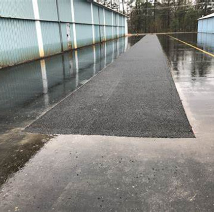
Permeable Pavers


Can be PICP (impermeable pavers with permeable joints/openings between) or AGGs (permeable pavers made up of aggregate material)
-
Flexible and proprietary.
-
Appropriate for: Residential and light commercial use, trails, pedestrian paths, and driveways. Capable of high vehicle loads. Used for lower speeds.
-
Construction Minimum layer requirements: Pavers on top of an aggregate base that is installed above infiltrating soils.
-
Easily replaced due to interlocking structure. Can be restored easily because gravel in voids can be replaced.
-
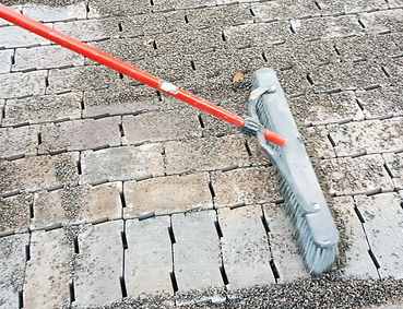
Maintenance: Sweep or vacuum when surface and debris are dry, 1-2x annually, Occasional pressure washing, as prescribed by manufacturer. Replace joint aggregate as needed.
Pervious Concrete

-
The only permeable pavement that is rigid.
-
Appropriate for: Heavier traffic loads. Works well for parking lots, bike lanes, driveways, and sidewalks.
-
Construction Minimum layer requirements: 6-inch minimum pervious concrete wearing layer on top of a 6-inch sand layer, with an aggregate base that is installed over infiltrating soils. Placement differs from conventional concrete—small batches of pervious concrete are feasible.
-
Maintenance: Prevent sediment from collecting on pavement. Clean surface annually with a combination of suction and sweeping.
-
General comparisons: Pervious concrete has less strength than conventional materials. Unless properly designed, it is more susceptible to freeze-thaw damage than porous asphalt. Sand should not be used for snow and ice conditions, but salt and deicing chemicals can be used in moderation.
Porous Asphalt
-
Flexible, non-proprietary (Similar to conventional asphalt, but fines in the mix smaller than ASTM sieve size # 30 sieve are reduced, if not eliminated.)
-
Appropriate for: Parking lots and streets with low-weight axle loads and light traffic volumes mostly due to inability to withstand rutting (e.g. local access residential roads, trails).
-
Recent experiments to incorporate fibers (Kevlar, carbon composite) have proved promising and suggest that these additives can expand porous asphalt applications to heavier traffic conditions.
-
Construction Minimum layer requirements: 4-inch minimum porous asphalt wearing layer on top of 6-inch sand layer, with an aggregate base that is installed over infiltrating soils.
-
Maintenance: Prevent sediment from collecting on pavement. Clean surface twice a year with a combination of suction and sweeping.
-
General comparisons: Porous asphalt has reduced strength compared to conventional asphalt and will not be appropriate for applications with high volumes and extreme loads. However, these pavements have less freeze-thaw stress than conventional pavements. Sand should not be used on these pavements, and salt and deicing chemicals must be used in moderation.
Plastic Grid
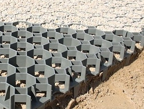

Series of interlocking plastic or synthetic grid filled with gravel or soil and can be planted with vegetation such as grass.
-
Flexible and proprietary.
-
Appropriate for trails, paths, maintenance access roads in parks, and parking lots. Capable of high vehicle loads. Best suited for low speeds and infrequent vehicular traffic
-
Construction Minimum layer requirements: Concrete or rigid plastic grids filled with topsoil/grass or gravel over an aggregate base that is installed over infiltrating soils.
-
Maintenance: May need to replace or replenish gravel if clogged or depleted.


Summary of Permeable Pavement Design Requirements
These site and design requirements can help you decide if permeable pavement might be appropriate for your project.
-
Permeable pavement is allowed on surfaces with slopes no greater than 5 percent.
-
Underlying soils should have a minimum infiltration rate of 2 inches per hour.
-
There are no setback requirements for permeable pavement.
-
There must be 5 feet between the high groundwater level and the excavated bottom.
-
The subgrade next to structures should slope away from the structures.
-
Use a minimum of 6 inches of washed, crushed 2- to ¾-inch or No. 57 rock under concrete or asphalt.
-
Consult the Stormwater Management Manual regarding required edge restraints.
For best results, keep in mind the following construction considerations:
-
Protect the subgrade from over-compaction during excavation.
-
Do not excavate or compact the native subgrade in wet conditions.
-
Consider the sequence of construction activities to protect the subgrade from traffic.
-
Protect the paving from construction traffic and sediment after installation.

When to Call a Professional
Call a professional designer if you have more vehicle traffic than a residential driveway.
Also, if your soil infiltration rate is less than 2 inches per hour, you will need to hire a designer to help you.

-
Prevent Clogging of Pavement Surface with Sediment
-
Vacuum pavement twice per year
-
Maintain planted areas adjacent to pavement
-
Immediately clean any soil deposited on pavement
-
Do not allow construction staging, soil/mulch storage, etc. on unprotected pavement surface
-
Clean inlets draining to the subsurface bed twice per year
-
-
Snow/Ice Removal
-
Porous pavement systems generally perform better and require less treatment than standard pavements
-
Do not apply abrasives such as sand or cinders on or adjacent to porous pavement
-
Snow plowing is fine but should be done carefully (i.e. set the blade slightly higher than usual)
-
Salt application is acceptable, although more environmentally-benign deicers are preferable
-
-
Repairs
-
Surface should never be seal-coated
-
Damaged areas less than 50 sq. ft. can be patched with porous or standard asphalt
-
Larger areas should be patched with an approved porous asphalt
-
Special Maintenance Considerations
Stormwater Regulations & Permitting
Municipal Stormwater Permits.pdf
DOE Pub: 23-10-033
Soil & Permeability
Facilities & Maintenence
Click logos below for stormwater information related to location.


Our Partners: